Sie haben keine Artikel im Warenkorb.
Motorboot Vaarkaarten
Het motorboot kompas is beter bestemd tegen trillingen en schokken. Ook bij hoge snelheden en golven lees je de kompaskaart nog eenvoudig af op je motorjacht. De meeste motorboten zijn uitgerust met een Plastimo Offshore kompas. De range bestaat uit verschillende maten en kleuren.
-
Plastimo navigatiekaart 3 The Marne – from Paris to Vitry – Le-François
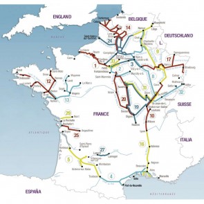
Each canal, river or navigable waterway is presented in the form of a cartographic atlas which includes, on each page, a portion of the route, accompanied by a text giving useful information on navigation, moorings, supplies and tourism. A technical description gives the characteristics of the waterway as well as advice on the best way to use the canals and locks.
Full-colour guides, at 1/25.000 or 1/50 000 scale, size 165 x 315 mm, range from 72 to 170 pages. Each guide features technical and touristic pictures. Texts are in English, French and German.
Mehr erfahrenRegulärer Preis: 35,50 €
31,95 €
-

Plastimo navigatiekaart 8 Champagne-Ardenne - from Namur to St-Jean-de-Losne
Each canal, river or navigable waterway is presented in the form of a cartographic atlas which includes, on each page, a portion of the route, accompanied by a text giving useful information on navigation, moorings, supplies and tourism. A technical description gives the characteristics of the waterway as well as advice on the best way to use the canals and locks.
Full-colour guides, at 1/25.000 or 1/50 000 scale, size 165 x 315 mm, range from 72 to 170 pages. Each guide features technical and touristic pictures. Texts are in English, French and German.
Mehr erfahrenRegulärer Preis: 30,50 €
27,95 €
-

Plastimo navigatiekaart 24 Picardy – rivers and waterways
Each canal, river or navigable waterway is presented in the form of a cartographic atlas which includes, on each page, a portion of the route, accompanied by a text giving useful information on navigation, moorings, supplies and tourism. A technical description gives the characteristics of the waterway as well as advice on the best way to use the canals and locks.
Full-colour guides, at 1/25.000 or 1/50 000 scale, size 165 x 315 mm, range from 72 to 170 pages. Each guide features technical and touristic pictures. Texts are in English, French and German.
Mehr erfahrenRegulärer Preis: 40,75 €
36,95 €
-

Plastimo navigatiekaart 9 Meuse, Sambre belge, East canal
Each canal, river or navigable waterway is presented in the form of a cartographic atlas which includes, on each page, a portion of the route, accompanied by a text giving useful information on navigation, moorings, supplies and tourism. A technical description gives the characteristics of the waterway as well as advice on the best way to use the canals and locks.
Full-colour guides, at 1/25.000 or 1/50 000 scale, size 165 x 315 mm, range from 72 to 170 pages. Each guide features technical and touristic pictures. Texts are in English, French and German.
Mehr erfahrenRegulärer Preis: 40,75 €
36,95 €